

Get here Notes based on the Class 6 NCERT Geography Chapter 1 ‘Locating Places on The Earth’. the chapter has three major Topics: Map and its components, Mapping the Earth and Understanding Time Zones. Click here for Question and Answers of this chapter ‘Locating Places on The Earth’.
Main Headings
hide
1. A Map and Its Components
An atlas is a book or collection of maps.
- Definition and Purpose of a Map:
- A map is a representation or drawing of an area, viewed from the top.
- It can depict a small area (like a village or town), a larger area (district or state), or very large areas (countries or the world).
- Types of Maps:
- Physical Maps: Show natural features such as mountains, oceans, and rivers.
- Political Maps: Display details of countries or states, boundaries, cities, etc.
- Thematic Maps: Provide specific information (e.g., population, climate).
- Components of Maps:
- Distance: Maps use a scale to represent real-world distances. For example, in Fig. 1.1, 1 cm on the map represents 500 meters on the ground.
- Direction: Maps use directional indicators (like the arrows in Fig. 1.1) to show north, south, east, and west.
- Symbols: Symbols are used to represent different features or places on a map.
- Map Scale:
- The scale of a map shows the relationship between distances on the map and actual distances on the ground.
- Example: In Fig. 1.1, 1 cm = 500 meters. In a map of India (Fig. 5.2 in Chapter 5), 2.5 cm might represent 500 kilometres.
Cardinal and Intermediate Directions
- Cardinal Directions:
- North (N), East (E), South (S), West (W).
- These are the main points on a compass.
- Intermediate Directions:
- Northeast (NE), Southeast (SE), Southwest (SW), Northwest (NW).
- These are the points in between the cardinal directions.
- Map Direction Indicators:
- Maps usually have an arrow marked with ‘N’ to indicate the north direction.

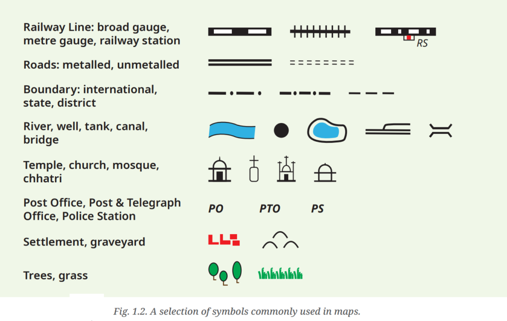
Symbols in Maps
- Importance of Symbols:
- Symbols represent various features on a map, allowing detailed representation within limited space.
- Different symbols are used for buildings, roads, natural features, etc.
- Standard Symbols:
- Different countries use different sets of symbols.
- The Survey of India has standardized symbols for maps of India.
2. Mapping the Earth

- Challenges of Mapping the Earth:
- Earth is nearly a sphere, not a flat surface.
- Flattening a spherical shape onto a flat surface (like a map) causes distortions.
- Globe:
- A globe is a spherical representation of the Earth.
- It accurately represents the Earth’s geography.
Understanding Coordinates
- Coordinates in a Market:
- Example: Giving directions in a market using rows and shops.
- Coordinates on a Chessboard:
- Chess moves are recorded using letters (a-h) and numbers (1-8).
- System of Coordinates:
- Used in maps to determine the location of places.
Latitudes
- Equator:
- An imaginary line halfway between the North and South Poles.
- Divides the Earth into the Northern and Southern Hemispheres.
- Parallels of Latitude:
- Lines parallel to the Equator.
- Measure distance from the Equator in degrees.
- Degrees of Latitude:
- Equator: 0° latitude.
- North Pole: 90°N latitude.
- South Pole: 90°S latitude.
- Climate and Latitude:
- Equator: Hot (torrid).
- Moving away from the Equator: Moderate (temperate).
- Near the Poles: Cold (frigid).
Longitudes
- Meridians of Longitude:
- Lines running from the North Pole to the South Pole.
- Measure distance from the Prime Meridian in degrees.
- Prime Meridian:
- 0° longitude.
- Passes through Greenwich, London.
- Degrees of Longitude:
- Measured from 0° to 180°, with E (East) or W (West) suffix.
- Example: New York – 74°W, Delhi – 77°E, Tokyo – 140°E.
- Longitude and Time:
- Longitude helps measure the time at different places on Earth.
- 180° Longitude:
- 180°E are the same longitude; so this longitude is noted 180°, omitting the letter W or E.
Grid System
- Combination of Latitudes and Longitudes:
- Together they form a grid system on maps.
- Helps in locating any place on Earth precisely.
- Example Coordinates:
- Delhi: 29°N, 77°E.
Historical Note on Prime Meridian
- Greenwich Meridian:
- Adopted in 1884 as the international standard.
- Ancient Indian Prime Meridian:
- Passed through Ujjain, known as madhya rekhā.
- Used by ancient Indian astronomers for calculations. Varāhamihira, a famous astronomer, lived and worked there some 1,500 years ago.

3. Understanding Time Zones
- Earth’s Rotation and Time Calculation:
- Earth rotates from west to east, completing a full turn every 24 hours.
- 360° rotation in 24 hours equals 15° per hour (360°/24 = 15°).
- Marking Meridians and Time Zones:
- Meridians of longitude are marked every 15°.
- Moving eastward from the Prime Meridian (0°): Each 15° adds one hour to local time.
- Moving westward: Each 15° subtracts one hour from local time.
- Example: If it is 12 pm at Greenwich (0°), it is 1 pm at 15°E, 2 pm at 30°E, and so on. Conversely, it is 11 am at 15°W, 10 am at 30°W, and so forth.
Activity Example
- Sunset in Gujarat and Assam:
- Porbandar (Gujarat) and Tinsukia (Assam) are approximately 30° apart in longitude.
- Since 15° of longitude corresponds to a one-hour difference in local time, 30° equates to a two-hour difference.
- If the sun sets at 6 pm in Assam, it would still be 4 pm in Gujarat, explaining the difference in daylight.
- Local Time vs. Standard Time:
- Local Time: The actual time at a specific place based on its longitude.
- Standard Time: A uniform time adopted by a country, usually based on a central meridian.
Indian Standard Time (IST)
- IST is 5 hours and 30 minutes ahead of Greenwich Mean Time (GMT+5:30).

Time Zones and Standard Time

- Time Zones on World Map:
- Countries adopt standard times based on meridians.
- Time zones broadly follow the 15° divisions but adjust for country borders.
- Countries may have multiple time zones (e.g., USA has six, Russia has 11).
- International Date Line:
- Located around 180° longitude, it separates different calendar days.
- Crossing it eastward subtracts a day (e.g., from Monday to Sunday).
- Crossing it westward adds a day (e.g., from Sunday to Monday).
- It deviates to avoid splitting countries into different days.
